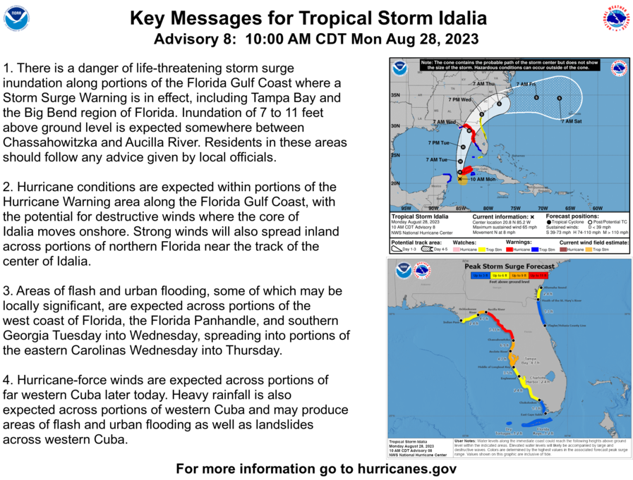
[Monday] Idalia Strengthening; Major Impacts Expected in Florida and Southeast US Beginning Tuesday


20 comments
« Previous Entry Next Entry »
Comments closed
Basic HTML is allowed.

Comments
Thank you! Great resource for decisions needing more urgency than the 2s and 8s. Not surprisingly, Bob Hart speaks highly of you!
I gather that a lot of forecasters aren’t taking this event as seriously as it deserves with their forecasts. Why some can lol at the gulf and its record warm waters and say we are only going to have a category 1 or 2 hurricane like they did yesterday is beyond any explanation I know. I remember how badly the forecasters missed Hurricane Michael all the way up to the very end and everyone was wandering where the storm came from because not many people had heard about it. Then almost immediately after the media started covering California wildfires and the storm’s aftermath was forgotten about in bizarre fashion. This storm has the potential to be a real threat; I don’t know why there is no mention of category 4 or higher potential. I appreciate the honesty in that this could be a significant event.
Unfortunately, the point of modern media has become to keep people watching and not to inform them…
This is most likely going to either be a high-end cat 3 or a low-end cat 4.
I wish you would pist updates more often
I trust you
Sorry meant POST
The amount of storm surge for the big bend of Florida has gone up to about 12 feet for the same areas. This is probably the worst case scenario that you could think of besides a cat 5.
With the hotter than normal temperatures I think this could be a Cat 5 at landfall. This will bomb out way before landfall.
Hi guys we are monitoring this system Idelia using all available resources.
Congradulations on a useful web program and successful meteorological journey.
If needing up to date weather information https://www.cassavaweather.com
I agree. water Temps are well into the 90s approaching 100 in the gulf. I believe once she emerges in the open waters she will really show her true colors and intensity will definitely go up!!! I forgot the name of the storm but the one in 2021 that was a strong 4 almost 5 off the coast of Florida and the water Temps then was 98°. luckily it weakened to a low end 3 before landfall south of Tampa Bay.. I believe this one will be worse and not weaken so much… I mean they still have it at tropical storm strength on the other side of peninsula.
Idalia certainly warrants close monitoring as it approaches landfall. I’d advise looking to qualified geometry dash weather services for the latest updates on its potential threats.
get your garbage posts out of here
I’d say Levi is more than qualified. Who are you to say he’s not? If you feel his information is insufficient look elsewhere, but don’t post garbage like this on his blog. Your parents must not have taught you if you don’t have anything nice to say, don’t say it.
Personally been following Levi’s blog for several years & I am a native Floridian. His info is good, & I send all my friends & family here. Levi was the first to come out yesterday & say this might be a major event & we are likely to hit a Cat 3. I only just started hearing this prediction this morning from your “qualified meteorologist”.
I’ll trust a dedicated well seasoned hobbiest over your fresh college graduate any day.
The person you’re replying to is attempting to send people to a potentially malicious link, they may have no knowledge in meteorology at all….
我们正准备迎接台风“苏拉”(Saola),你们可以在这个网站上看到这个台风。我们现在很关心它到底会在哪里登陆,毕竟上次台风“杜苏芮”(Doksuri)登陆的时候,一直到它登陆前18个小时,我们的气象台才得以正确地预测出它所要登陆的城市。看来人类想要预测一个风暴的走向确实是具有很大难度的。。祝你们好运。
Great information this website is amazing and truly a godsend. I believe Dr Levi is one of the most intelligent and insighful Meteoroligist today. Appreciate your work!
I stumbled on ur site the day before yesterday. WoW what an awesome site you have.
My go-to site from this point forward. You have a lot of awesome ways and resources to
show ur viewers what’s, what.
Keep up the great work. I will be telling everyone about ur site (how awesome it is)
Thank you for doing such a great job, and letting us experience this awesome resource.
Jay.
Groping for some positive news for coastal FL, so:
– current real time radar shows her moving at a pretty good clip
– track is due north, but with a recent and ever so slight nod to the NNW
– the meaning of Idalia? “Behold the Sun”
Best of luck to all!
I have been working with computer models for years and they have improved enormously, especially the European and Canadian models. I designed and built the first weather station on the Continent of Australia. I do not buy into the notion that surface temps are the primary factor in strengthening. In this storm, there are other factors which include southwest steering currents and a weaker northwestern wall of storms. This creates a situation where the storm is squeezed further north than initially forecast. I think this will move perhaps five degrees more toward the panhandle. Aside from the storm surge, the tracking goes through relatively low-populated areas. Once landfall occurs which I suggest will be north of Cedar Key, there is no feeder for the northeast wall so the storm will diminish rapidly to a tropical storm. I also expect the speed of the storm to pick up to 20 mph. That generally does not aid the cyclone in building higher wind speeds.
I also think Levi does a magnificent job explaining the many variables in his videos. He is cautious as he should be to changing conditions and never ventures into hype. Leave that to the media populists. The media is still predicting Tampa as the landfall target. That’s highly unlikely.
Those of you enamoured with speed and calling for CAT this or CAT that, don’t seem to have much feel for the beauty of cyclones and their individuality. In modern America, every storm is hyped to be the next big record holder. Perhaps look at the record books. Hurricane Fifi was a Cat2 storm in 1974 that killed 8000 people. Other major storms with the exception of Mitch in 1998, occurred mostly in distant history of 100 years or more ago.
Good forecasting is supposed to lead to greater efficiency. In recent years in Florida, more people have been killed on highways from unnecessary evacuations than the storms themselves. I believe this is due to media hype that is intended to scare people. I am sorry I do not have the answer on how to change this. Politicians, the intellectual bottom rung, call for evacuation, very often completely unnecessary and endanger the public. They give themselves prizes as the highway death tolls rise. I am sorry, I have no solutions for any of this.
My weather station was used by the US Navy 7th Fleet. They were not prone to hype or exaggeration. Best wishes to all in the Cedar Key area. Grand work Levi.
I really appreciate these videos and the way they are made! The information is presented in a way thats very straight forward, honest, and informative. I wish every news outlet or weather channel would operate like this. Bravo Levi and please keep up the good work!