 Support TT
Debby Weakens but Still Soaking Florida – Atlantic to Turn Quiet after She is Gone
Debby continues to meander slowly in the NE Gulf of Mexico this morning, and is currently drifting ENE. Convection has waned throughout the core, a function both of the continued wind shear that was talked about yesterday and cold upwelling of the ocean due to Debby’s stalling for so long in the same area. She has weakened since yesterday and now has only 50mph winds, though rains on the eastern side continue to affect Florida, where flooding has been a problem. Florida will continue to receive more rain until Debby’s center crosses the peninsula, which is where Debby is now headed.
The track forecast for Debby within the last 36 hours has gone from every model except for the GFS and the NHC track itself taking the storm into Texas, to a swing eastward over Florida, and yesterday afternoon I was forced to change my track as well. Although this was likely the most difficult track forecast we will have to make this entire year, and the possibility for a Florida landfall was always on the table, it was still a bust, and something to learn from. I show in the video the most logical reason for why the forecast failed, that being the pattern amplification over North America that was not conducive for a ridge orientation that could block Debby underneath. Overall Debby’s forecast was a mixed bag, as we have been talking about her development for a full 2 weeks with the potential for an Allison-type rain event for the gulf coast, and this along with the intensity forecast verified, but the track did not come through.
Debby will be taking her sweet time in crossing the Florida peninsula, and once on the other side the state will likely dry out, but Debby may still move very slowly and hang near the Gulf Stream for a while, possibly restrengthening. The latest Euro bombs her to a major hurricane over the Gulf Stream, but the pattern with the trough over the east coast would prevent a 2nd landfall, and will likely steer her northeastward out to sea eventually.
After Debby, the Atlantic will turn quiet again as the MJO starts to leave the basin. The upward motion provided by the MJO is rather necessary before August to get any significant development, and until the MJO comes back around to the Atlantic, much of July may be uneventful. In general, as we get closer to the peak part of the season, activity relative to normal should decrease, typical of El Nino seasons, which favor development early and then tone it down during the peak of the season.
Although this was the fastest start to the hurricane in the record books in terms of storm count, Debby was the first truly tropical development of the year, and this is nothing like the 2005 season. This season should still end up near or slightly below normal in terms of overall activity, with the potential for slightly inflated number totals due to all of the subtropical-based developments that we had in May and June. Indeed, the last time a season started this fast before July was 1968, when 3 storms formed before July, but in the end the season total was only 8 storms. Unsurprisingly, this was also an El Nino year, and this season should follow the same general path, though I expect storm totals will be 10-12 by the end.
We shall see what happens!
18 comments
Debby Bringing TS Conditions to Florida, Track Remains Uncertain
Update 4pm EST:
We finally have a model consensus. The 12z suite all flipped to Florida, and at this point in the game, they are more than likely correct. Had Debby’s center been but 50 miles farther southwest this morning, it would have been different. 50 miles is all it took, and that’s why this has been such a tough forecast. Debby’s northeast movement into the Florida panhandle will be lethargic, and although she likely won’t be able to become a hurricane, the copious amounts of rainfall in the sunshine state will more than make this a very dangerous storm.
The plot thickens this morning as Debby drifts slowly northeastward in the NE Gulf of Mexico, bringing tropical storm conditions the Florida panhandle. Debby still has an exposed center due to southwesterly wind shear, though the circulation has become better-defined overnight. Winds are around 60mph, a strong tropical storm, and Florida will be dealing with heavy rains and strong winds for the next couple of days regardless of Debby’s track. If Debby moves NE into the Florida coastline during the next 48 hours as depicted by the GFS, wind shear due to the proximity of a shortwave trough to the north will likely keep Debby below hurricane strength. However, if a turn to the west occurs and Debby has 3-4 days over water, upper-level conditions will likely improve due to an upper low backing southwestward in the western gulf, and hurricane intensity would be likely at some point.
Debby’s track forecast is even lower confidence this morning since the 0z runs of the UKMET, CMC, and ECMWF all made shifts to the east. The ECMWF and UKMET still turn Debby westward but then lift her northward into Louisiana. The GFS and some other hurricane models take her northeastward into the big bend of Florida. I am not ready to give up on a westward turn based on one model cycle, and it will be enlightening to see today’s 12z and tonight’s 0z runs, which I will likely be posting on the Facebook feed as they come in today. The NHC track last night showed a Texas landfall, but as of 11am EST has shifted to Louisiana following the ECMWF. My forecast philosophy remains that the plains ridge will build far enough east to stall Debby for the next couple of days in the NE Gulf of Mexico with little movement, and an eventual turn towards the west, just south of the Louisiana coastline, though perhaps closer than expected before. I’m not sure I buy the track northward into Louisiana directly into the ridge, and this track may be simply a product of the models finding a middle ground while fighting over the west or northeast tracks. However, as with all of the track possibilities we have with this storm, it cannot be discounted, and as I have had to say over the last few days, the entire north gulf coast should be prepared for a possible landfalling tropical storm or hurricane within the next few days. Florida will be dealing with tropical storm conditions regardless of what happens. This is perhaps the most difficult track forecast we will have to make this entire year. I will continue updating as the situation evolves. You can keep up with my short update posts here.
We shall see what happens!
Auto-updating Rapid-scan Visible Satellite Loop:

14 comments
Debby Likely to Form Today
We are still watching invest 96L in the central Gulf of Mexico for development into Tropical Storm Debby, which should occur sometime later today. A recon plane is currently investigating 96L to see if the circulation has become defined enough to call it a tropical storm. You can follow live recon data on my recon plotting page throughout the next few days. The center of 96L is still exposed as convection is being sheared to the east by an upper low in the NW gulf. However, this upper low will be backing southwestward towards Mexico over the next couple of days, and a southwestward-moving upper low in the face of a tropical system to its east is usually a favorable or at least improving situation, and thus I expect wind shear will relax somewhat over 96L during the next 48-72 hours, probably not entirely, but enough to allow further gradual organization.
96L will be stalling southeast of New Orleans for the next day or two deciding which way to go. The models are amazingly still split on the track even though the fork in the road is already upon us. That is how close the ridge/trough setup to the north of this system is, and the computers still don’t agree on which feature will capture the storm and steer it. Due to the setup with two troughs, one on each coast of the U.S., and the known northeastward feedback bias that the GFS has, I still believe 96L will eventually get caught underneath the Texas ridge and be brought westward into the NW gulf of Mexico, a solution still supported by the ECMWF, UKMET, and some of the hurricane models. However, until the models reach a consensus, either my track or some other track, the other possibilities cannot be discounted, and the NE gulf coast should still be wary of a possible tropical cyclone landfall during the next few days. Regardless of where 96L ultimately decides to go, heavy rains and tropical storm-like conditions will spread over parts of Florida and the north gulf coast during the next couple of days.
If 96L ends up moving northeastward into Florida, conditions don’t seem likely to allow intensification into a hurricane, and a moderate-strong tropical storm would seem most probable in that scenario. However, if 96L does move westward towards Texas as I expect, the length of time over water and slightly improved upper-level environment could allow strengthening into a hurricane, but that is still several days away, and we will know more once 96L finally picks a track.
Overall, this is a classic early-season development that is taking its time organizing as a sheared system, but there is potential for a stronger storm to develop if it can consolidate the large amount of energy in the Gulf of Mexico. The track remains uncertain, and although my forecast is for a NW gulf coast landfall, the entire gulf coast still needs to monitor this storm closely.
We shall see what happens!
Auto-updating Rapid-Scan Visible Loop:
27 comments
96L to Become Debby and Bring Rain to East-Central Gulf Coast Regardless of Track
Invest 96L, what promises to be one of the greatest forecasting challenges this season, continues to slowly organize north of the Yucatan Peninsula this morning. The only significant batch of convection associated with it is removed east of the center over the Yucatan Channel. A new lobe of low pressure will likely develop within the broader circulation close to this area of convection and move northward during the next 24-36 hours, eventually dragging the rest of the broad circulation with it. Consolidation of the system will be slow, but it should steadily organize with time as it moves slowly northward to a position southeast of New Orleans during the next 2 days.
By Sunday, 96L will likely stall and not move much for a little while as it decides which way to go. The models are still split on whether 96L will move northeast across Florida into a trough over the eastern seaboard, or whether it will be captured by the Texas ridge and brought westward. I am still of the mind that the westward track is what will eventually occur, with a track taking what should be Debby into southern Texas or northern Mexico. Yesterday more of the global models came back into agreement with this idea, and last night’s 0z runs of the ECMWF, UKMET, and CMC all support that track. However, the ensemble means reveal a very low-confidence forecast, with the ensemble members spread from coast to coast across the Gulf of Mexico with 96L’s future track. Thus, there is still no real consensus, and the models are still deciding what to do with the system. As I mentioned yesterday, the trough that will be over the western U.S. coast makes me wary of the idea that the eastern trough can exert a strong influence over the central Gulf of Mexico in the face of the big Texas ridge between the two troughs. It is also difficult for such a trough to drag such a large monsoonal low northeast out of the deep tropics. While more models currently support my forecast, the northeast track into Florida cannot be discounted, and regardless of track, heavy rains will be spreading through Florida and likely the central gulf coast as well during the next 3-4 days.
96L will take its time strengthening due to its size, and a track into Florida likely wouldn’t give it enough time to become more than a moderate tropical storm. However, if 96L stalls in the central gulf and then takes my track westward, it may have enough time to take advantage of lower wind shear and become stronger, possibly becoming a hurricane in the western gulf, but not much can be known about the peak intensity of this storm until it has developed and we have more confidence in its track and timing. For now, the entire gulf coast should keep a close eye on this system.
We shall see what happens!
Auto-updating Rapid-scan Visible Satellite Loop:
18 comments
Gulf System Likely to Eventually Become Debby, Track Still not a Given
The Gulf of Mexico is coming to life as low pressure is now developing in the central part of the gulf. The developing circulation is still elongated with one lobe of low pressure west of Key West and the other down near the NW coast of the Yucatan Peninsula, acting as a trough extension to the monsoon low over central America. The area is still experiencing moderate wind shear, but the shear has relaxed to below 10 knots near the Yucatan Channel as an upper ridge starts to build northward in the wake of the retreating upper low over Florida mentioned yesterday. The environment will be slowly improving with time, and should allow the eventual organization of this disturbance into tropical storm Debby in a few days.
The track of this system remains the biggest question, as the models are split about in half on whether it will move into the NW gulf or escape northeast over Florida. My forecast remains that the system will get caught by the Texas ridge and move in the NW gulf, making landfall in southern Texas or northern Mexico. However, the northeast escape route cannot be dismissed either, so the entire gulf coast, especially Texas and Florida, should be on alert for the possibility of a landfalling tropical cyclone early next week. Florida is already set up to get tons of rain from this system regardless. In the video I show the current model projections and why I am sticking with the westward track. This is a particularly difficult forecasting situation, and any forecast won’t have a high degree of confidence until the models finally form a consensus on the track.
One thing the models do agree on now is that this system should develop into a tropical cyclone of some kind. The CMC and ECMWF are taking the storm to hurricane strength, which may be overdone, but it raises the concern over how long this disturbance will be sitting in the gulf. The models keep pushing the time frame back due to how long the system stalls waiting for the east coast trough, and we’re still talking about 5-7 days or more before this is out of our hair. With that much time, it is possible that the storm will have enough time to come together and become stronger than originally thought, but we will know more about the potential strength after the track is better-known, for that will affect the intensity as well.
Overall, the gulf coast should be watching for at least a heavy rain event that will affect Florida regardless of what the track is, and should move into the NW gulf by early next week, affecting at least the south Texas and north Mexican coastlines. Again, though, the northeast gulf should be watching the situation closely as well, for the northeasterly track option cannot be discounted yet in such a tough forecasting setup.
We shall see what happens!
32 comments
Gulf Disturbance to Meander and Bring Rains to the GOM Region
An area of low pressure is beginning to develop just southwest of Key West, Florida. The developing center remains exposed with most of the thunderstorm activity off to the east due to moderate wind shear still over the Gulf of Mexico. This should lighten a bit over the next several days, but due to the elongated shape of the area of upward motion, shear will likely be a problem for this system for the rest of its life. Despite the shear, the surface low should slowly become better defined with time over the next few days, and development of a weak tropical storm is still very possible, though it should remain weak. Heavy rains are currently affecting central and southern Florida, the Bahamas, and Cuba.
The forecast for this system is defying the natural laws and becoming more difficult as crunch time gets closer, instead of easier. The models are more split than ever this morning on the system’s future. More models have joined the GFS in trying to take the system out to the northeast over Florida into a trough along the eastern seaboard in 4-6 days, after meandering around in the central gulf for a while. I’m not ready yet to give up on the system getting caught by the Texas ridge and making it into the NW quadrant of the gulf, and the NAEFS ensemble and JMA still support that idea. The models are almost perfectly split in half on which path the system will take. Either one fits perfectly with the Allisons of 1989 and 2001 analogs. The latter in 2001 got blocked by the Texas ridge and then scooted off to the northeast into a trough over the eastern seaboard. The difference from the Allisons here is that our development is coming from farther east and may not get a chance to affect the northwest gulf if the trough catches it. Right now I am not going to sway with the models because they don’t know what they’re doing yet, as evidenced by their disagreement. What we need is for this disturbance to be tagged an invest so that the models can be initialized with the correct coordinates of the low center and then let them run. Hopefully this will happen soon. If you ever need an example of why designating invests is necessary, think of today. Specialized model runs are wonderful.
Overall, this system is not a big worry in terms of wind, as it should remain a weak system in general due to less than ideal environmental conditions, and the main story will be the rainfall that it is bringing to the gulf states. Whether the western gulf gets some will depend on whether the system actually moves in that direction instead of getting caught by the trough and moving northeast. I am still of the opinion that it will take the western road, but again, without unified computer support, the other option is on the table, and we should watch for that as well.
We shall see what happens!
Self-updating Visible Satellite Loop:
8 comments
Caribbean Disturbance to bring Rain to the GOM, and may Develop
We are continuing to monitor the Gulf of Mexico for tropical development later this week, through the weekend, and into early next week. We now know the instigating disturbance is a tropical wave coming northwestward out of the Caribbean into the central-eastern gulf while interacting with the monsoon trough over central America. Right now a broad, elongated area of showers and thunderstorms is covering the Caymans, Cuba, and the Bahamas. This activity will be spreading northward over the next couple of days, encompassing all of the Bahamas and Florida, bringing heavy rains of many inches to some places. At this moment, only a weak mid-level turning is noted the western Caribbean, with most of the associated convection sheared off to the east, and overall the area is a complete mess right now. However, an upper low over the central Gulf of Mexico will be moving northward out of the way during the next 72 hours, allowing another upper low over northern Mexico to ventilate the gulf and allow an upper ridge to expand northward, lowering wind shear and providing a more favorable environment for consolidation of a tropical low. Due to the elongated nature of the pattern we are dealing with, the setup will likely not be optimal, but should be favorable enough to allow gradual development.
The models are still heavily diverging on the fate of this system immediately after 48 hours out, which is an impressive disagreement for the time period being so close to us now. The GFS for a couple of days now has started taking most of the moisture out to the northeast over Florida and into a trough over the eastern seaboard, while letting the low in the Gulf of Mexico die at 90W. I attribute most of this forecast behavior to a typical GFS bias where the model tends to throw the energy away poleward into a trough that it deepens too much into the tropics, an error that it makes a lot during strong MJO pulses. The GFS’s MJO forecast is also unrealistically strong in phase 1, which is likely causing feedback problems in our area of the world, which immediately calls into question its forecast in the tropics for the next several days. The CMC had previously taken the low northward towards the Carolinas as well, but such forecasts I am dismissing as unrealistic at this point. Most of this activity should eventually shift westward into the NW Gulf of Mexico with time, under a pattern very similar to Allison in late June 1989 as we have been discussing recently. The NAEFS and CMC ensemble means continue to support this idea.
Should this system develop, it will take its time in organizing, and likely won’t get terribly strong, unless it gets more time over water than expected, but a tropical storm is very possible in this pattern, and environmental conditions will be improving with time over the gulf. Development or not, a shot of rain is likely to get into the NW gulf and affect at least south Texas and northern Mexico. Rain will be harder pressed to get as far north as Houston and Louisiana, but that will depend on the exact track of the system once it gets into the gulf. Interestingly, many forecasts along the NW gulf coast are calling for sunny conditions for the next week, and it will be interesting to see if they get surprised. Overall, the general idea that we have been working on for the last couple of weeks has not changed, and a development threat in the western-central Gulf of Mexico will be spreading rain around from east to west as we move through the end of this week and into early next week.
We shall see what happens!
Don’t forget to follow my page on facebook for more frequent short updates (tidbits) on the tropics.
Self-updating Visible Satellite Loop:
11 comments
Tropical Development Likely to Affect Western Gulf of Mexico in 6-10 Days
As we have been talking about for a while now, tropical development is still favored in the western Gulf of Mexico later next week and into next weekend. The monsoon trough in the eastern Pacific and western Caribbean will be slowly swelling northward with time into next week, and the fact that Hurricane Carlotta in the eastern Pacific is moving close to the Mexican coastline instead of out to sea illustrates that this is already beginning to occur. This pattern is being strongly supported by an intense MJO wave moving into phases 8 and 1, and it is this kind of support that most Atlantic June storms form under. The pressure pattern over North America and the western Atlantic favors low-level convergence (piling up of air) in the western gulf, and this, combined with the strength of the oncoming MJO, is why I have been adamant about the significant possibility of tropical development, despite only little model support. The models are slowly coming more onboard now, with the CMC, GFS, NOGAPS, and at times the ECMWF showing at least a closed low developing of some kind. The ensemble means continue to strongly support a very wet and convective pattern in the northwest gulf in about a week’s time. Sea surface temperatures are also running 1C above normal in the entire western gulf, 28-29C in most areas, and would provide plenty of fuel for tropical development.

The video above details the overall setup that should lead to an attempt at development. The exact timing and location of such a development still can’t be known over a week out, but the general idea here continues to be that the western gulf should light up with activity that could bring heavy rains to northern Mexico, Texas, and Louisiana, very similar to the patterns of Allison in June 1989 and Allison in June 2001. The same kind of blocking pattern could either cause a potential storm to stall near Texas as the Allisons did, or it could simply turn the storm westward into Texas or Mexico. The models currently favor the latter scenario, but this will be determined by the exact timing of development and how far north the potential system gets. The overall idea to keep in mind right now while we are still 6-10 days away is that the northwest Gulf of Mexico is going to get a shot of significant tropical activity, with a significant possibility of the development of a tropical storm, and at least a bout of heavy rains regardless.
We shall see what happens!
18 comments
GOM Development Possible Late Next Week – Ghost of Allison?
The developing pattern continues to look favorable for tropical development in the Gulf of Mexico later next week as the MJO moves into phase 1, lending upward motion support to the western Atlantic, which is usually necessary for getting a June development. The ridging pattern over the Great Lakes also supports piling up of air to the south of the United States, which leads to upward motion and lowering of pressures in the Gulf of Mexico, and this is being echoed by all of the models. What the models are not seeing consistently yet is actual development of a storm, with only last night’s CMC currently showing one, but we are still 7-12 days away. The models will likely become more consistent one way or another once the MJO stops racing across the Pacific and settles down in phase 1, which it is forecasted to do.

Figure 1. 0z CMC 240-hour forecast
The pattern looks very similar to when Allison formed in June 1989, as well as the more recent Allison in June 2001. Here are their tracks:


Figure 2. The tracks of the Allisons of 1989 and 2001.
Both storms were very similar, both moving quickly into Texas and then getting blocked, causing flooding. In the video I show the pattern that led to the blocking of both storms and compare it to the similar ensemble forecasts for next week, and the retrogressive pattern that occurred during both Allisons is supported by the currently very progressive MJO. This is a pattern that favors development more than usual for June standards, but even further than that, we may have to watch for the ghost of Allison with this setup, where a quick-hitting storm tries to develop in the gulf, move inland, and then potentially get blocked, either over land or water, causing a heavy rain event for the gulf coast.
We shall see what happens!
11 comments
Atlantic quiet for now; Watching for GOM Development June 18th-25th
The Atlantic is currently quiet, with the only feature of interest being an old frontal boundary over the northern Gulf of Mexico that poses no significant threat for tropical development over the next few days, though it will bring rainfall to the gulf coast. As discussed back when Beryl was making landfall in Florida, the first half of June here is quiet, and will continue to be so through at least the 15th.
However, the signs for the next round of tropical activity have already been showing themselves, as the MJO is unanimously forecasted to come back into phases 8 and 1 in 10-15 days, bringing upward motion back to the Atlantic. At the same time, the models are forecasting anomalous ridging to develop over the Great Lakes and Hudson Bay region, and the fact that these anomalies are that far north means we have to watch to the south of the ridge for tropical activity in the Gulf of Mexico and northwest Caribbean. All of the ensemble means show a significant lowering of pressures in the region after Day 10, with about half of the GFS ensemble members and CMC ensemble members all showing tropical development of some kind during the 10-15 day period.
The CPC analogs based off of the GFS ensemble Day 11 forecast are also very interesting. Looking at the top 3:
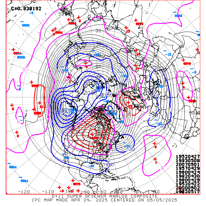
1) June 23rd, 1989 – Allison developed the next day and moved into Texas.
2) June 2th, 2005 – Arlene developed 6 days later and moved into Florida as a near-hurricane.
3) June 27th, 1975 – Amy developed in the Bahamas and moved up towards North Carolina.
So one can see that in very similar patterns to the one we are headed into, development has occurred multiple times. We always have to watch to the south of big ridges over the Great Lakes, as it usually means trouble of some kind. Notice that when Alberto and Beryl formed, a blocking ridge was found to their north over New England and the NW Atlantic, but here the ridge is shifting west, implying that the development region should shift west with it, and the Gulf of Mexico will have a shot at early-season development. Details on any potential development here will remain vague for a while since it is still a long ways out, but the period of June 18th-25th will likely see a significant uptick in activity in the northwest Caribbean and Gulf of Mexico.
We shall see what happens!
22 comments